


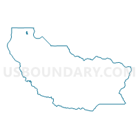
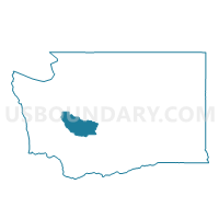
Voting District 26-204, Pierce County, Washington
About
Outline

Summary
| Unique Area Identifier | 688292 |
| Name | Voting District 26-204 |
| County | Pierce County |
| State | Washington |
| Area (square miles) | 0.56 |
| Land Area (square miles) | 0.56 |
| Water Area (square miles) | 0.00 |
| % of Land Area | 100.00 |
| % of Water Area | 0.00 |
| Latitude of the Internal Point | 47.36207610 |
| Longtitude of the Internal Point | -122.61954370 |
Maps

Graphs
Select a template below for downloading or customizing gragh for Voting District 26-204, Pierce County, Washington


Neighbors
Neighoring Voting District (by Name) Neighboring Voting District on the Map
- Voting District 26-201, Pierce County, WA
- Voting District 26-216, Pierce County, WA
- Voting District 26-217, Pierce County, WA
- Voting District 26-221, Pierce County, WA
- Voting District 26-231, Pierce County, WA
- Water: Carr Inlet, Pierce County, WA
Top 10 Neighboring County Subdivision (by Population) Neighboring County Subdivision on the Map
Top 10 Neighboring Place (by Population) Neighboring Place on the Map
- Gig Harbor city, WA (7,126)
- Rosedale CDP, WA (4,044)
- Canterwood CDP, WA (3,079)
- Purdy CDP, WA (1,544)